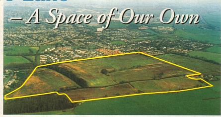
When Bunkers Lane Open space, an area of about 50 hectares, (123½ acres) was acquired by Dacorum Borough Council for the use of the people of Dacorum at the end of 1995, it effectively secured a part of our local heritage. In the latter part of the twentieth century the land had been acquired by the Commission for New Towns ( now English Partnership) for the purpose of developing the New Town of Hemel Hempstead.
However, fortunately for us all, and despite several attempts to have the area developed for housing, the expansion of Hemel Hempstead fortunately did not include this land, which has been shaped and exploited as agricultural land for at least 2000 years.
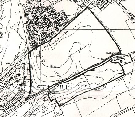
Chambersbury Lane, which forms the northern most (NW) boundary and marking the edge of residential area of Leverstock Green, and Bunkers Lane which runs virtually parallel to it and is shown above by a dark line separating the near rhombus shape of the bulk of the site from the smaller virtually rectangular section to the south, are both ancient lanes or track ways. Until fairly recently it was assumed these lanes dated back to Anglo Saxon Times or the early middle ages.
Their relative age was, and still is in the case of Bunkers Lane, easily apparent to anyone walking or driving their length and seeing the extremely well established ancient hedgerows delineating the sides of the lanes. Additionally the lanes themselves show obvious signs of having been used for many centuries, as the road way has been down cut by continual usage in many places, leaving the fields on either side at a higher level than the road. The lanes themselves (prior to widening in places, particularly Chambersbury Lane) were also narrow and obviously predated the internal combustion engine.
A glimpse at an early Ordnance Survey map reveals the lanes to have been part of the narrow furlong strips which cover this part of Hertfordshire, and which undoubtedly formed part of the early medieval field system, and were most probably also part of the Iron Age landscape. The ancient nature of Chambersbury Lane being born out by the hedgerow study I undertook along Chambersbury Lane in September 1994. This was prior to the drastic cutting back of the hedge, which was deemed necessary in order to correctly manage the hedge as part of the park and to the benefit of wildlife.
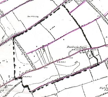
This map is an extract from the 1877 6 inch to one mile Ordnance Survey map with the still then existing furlong boundaries shown in violet. Some of these areas till visible today. (See photo at beginning.)
Note that the ancient strips of Winchdells Common which showed up on the 1840 Tithe map still exist, but that field boundaries generally have changed, and a woodland strip (still in Bunkers Park today) has been introduced from Catsdell Bottom.
Using established criteria for hedgerow dating, and studying the section of hedge, which ran from the present entrance to the Park to a little past the entrance to the Northend Estate, I dated the hedge along Chambersbury Lane to the early 10th century. Details can be viewed by clicking here. Along this length too there tended to be oaks at regular intervals, with the massive oak opposite the entrance to Northend Farm being likely to be between 400-600 years old. This tree is now on the Herts. Veteran Tree Register.
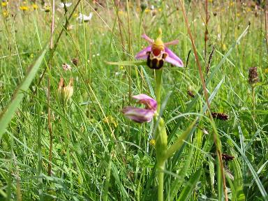
Although a formal hedgerow survey has not been carried out along the hedges bounding Bunkers Lane, it is obvious from just driving past at different times of year, that the hedges contain many differing species, and indicators of ancient hedgerows such as Hazel, bluebells and Yellow Archangel. Additionally lines of hedgerows between the lanes can still be traced (if only in part) show the furlong field boundaries quite clearly.
It is therefore fairly certain that this land was ploughed and planted with crops for much of the past 1000 years. There are also recent indicators that the lanes at least date back not 1000 years but 2000 years plus. Recent archaeological discoveries along Westwick Row Leverstock Green, & Silverthorne Drive make it extremely likely that the cultivation of the land dates back to Iron Age times, and that at the very least, the two lanes were Iron Age track ways forming part of a well established Iron Age landscape in these parts. The finds of Iron Age as well as Roman material at Handpost Lodge Westwick Row, and in the garden of Silverthorne Drive provides a strong likely link between the two in both Chambersbury & Bunkers Lanes. (See map). Further study of the earlier Ordnance Survey maps where the still existent lines of field boundaries can be seen, shows the boundaries to be bisected by the known Roman Roads, and therefore predating the Roman period. Archaeologists who studied the finds at Silverthorne Drive this summer (2001) believe there to have been a well established Iron Age settlement of some kind at the site, which was closed down by the Romans once they'd taken over and imposed Roman "order" on everything. The Handpost Lodge site indicates the likelihood of a Roman villa (i.e. a high status Roman farm complex) overlying an Iron Age site. The two are linked by the "line" of Chambersbury Lane, the full extent of which is still more or less preserved in our present roads and footpaths (and shown clearly on old OS maps). It therefore seems possible that the Romans closed down the settlement at Silverthorne drive, moving the personnel closer in to the main farmstead where they could be kept an eye on, and from which the already cultivated land nearby could be managed. The Romans probably created smaller "square" fields out of the previous long furlong wide strips, but the essential boundary lines remained to be reinstated into long strips in Anglo Saxon and Medieval times. However, it is also possible that the medieval farmers utilized both the squarer "Roman" fields, and the older boundaries, merely dividing each small square field into strips, a pattern still visible within the area of Bunkers Park at the time of the Tithe Survey in 1840. (See map lower down.)
By the time the Medieval Abbey of St. Albans) was well established, (founded in the 8th century, with the present Abbey Church dating to 1077) the land of Bunkers Park, together with other land locally, had been formed into the sub-manor of Chambersbury and belonged to the Abbey. The land must have been productive, as it was used to provide income for the Rectory attached to the Parish of Abbots Langley (St. Lawrence) and was otherwise known as Rectory Manor.
A detailed history of the Manor of Chambersbury (estate) can be found here but the manor house was to be found at the junction of today's Chambersbury Lane and Bedmond Road, and so more or less adjacent to what is now Bunkers Park. Remaining a sub-manor in the possession of the Abbey until the Dissolution of the Monasteries, when the lands were taken into Crown ownership.
Following the dissolution of the monasteries, Henry VIII sold the manor to his embroiderer William Ibgrave. The receipt for this sale being found in the 1940's among some old papers of Mrs. Reynolds Solly of Abbots Langley.
In 1605/06 the manor of Chambersbury once more reverted to the Crown on the death of William Ibgrave, grandson of the first William who was the King's embroiderer. James I then granted Chambersbury to Edward, Lord Bruce of Kinloss, and Master of the Rolls.
When in 1611 Lord Bruce of Kinloss died, the manor had previously been settled on his wife for the remainder of her life, after which it was entailed to his 2nd son Thomas. (Entailed property passes down through the male heirs from one generation to the next.)
In May 1624, with the agreement of Thomas Bruce, his mother and her new husband Sir James Fullerton, the Manor of Chambersbury, (along with the Manor of Sarrett) was sold to Thomas and John Child, who were already the owners of the Langleybury estate. The tenant of the manor at that time, by which it can be assumed is meant the Copyholder, was a Raphe Elsby, who paid the Childs a quit rent of "vi shillings of lawfull Englishe money". In September 1624 William Knolton, an attorney concerned with the conveyance of Chambersbury, took possession of Chambersbury manor house. This was presumably a device whereby the lawyer took legal possession of the estate on behalf of his clients, Thomas and John Child. The farms themselves (Chambersbury & Bunkers or Bunchers) were however sold as Copyright properties to others such as Jeremiah Smith (Chambersbury) and the Howe family a Bunkers. Memorial inscriptions to the families can be found in St. Lawrence's Church at Abbots Langley.
In January 1713/14 the lands of the Manor of Chambersbury, (i.e. the Freehold) with nine score acres of Arable, woods, the Rectory and advowson of Abbots Langley, were sold to Sir Robert Raymond who also acquired the Langleybury Estate, but by the mid 19th century the Manor was in the hands of Samuel Reynolds Solly, otherwise known as Squire Solly. The copyholder and occupier of the lands now known as Bunkers Park were however members of the Field family. The Fields had been a very important local family in earlier centuries, being Lords of the adjoining and tiny Manor of Leverstock Green in the 17th century until it was sold to the Grimstons at Gorhambury.
In 1835 Ann, the widow of Thomas Field died leaving the copyhold of Bunkers to her son John. He was listed in the Tithe survey as being the copyholder as well as the occupier of part of both Bunkers and Chambersbury (John Dickinson held that part of the farms nearer to Nash Mills, farm which he formed his abbots Hill Estate) The tithe apportionments show the land to have been largely arable with some woodland. The 1841 census specifically recorded John Field as a farmer, so it is fair to assume that it was John Field who farmed the Bunkers Park land in the mid 19th century.
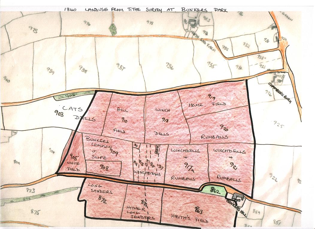
MAP SHOWING THE LAND USE IN THE BUNKERS PARK AREA AT THE TIME OF THE TITHE SURVEY, 1840.
During the First World War, Bunkers farm was used to billet members of the Queens' Westminster Rifles whilst they were stationed in Leverstock Green prior to their departure for France. (See http://lgchronicle20.homestead.com/QWR.html)
Joseph Bailey Senior was to die in June 1922, but his son, another Joseph, carried on farming the land for many years to come. He farmed the land from Catsdell to Bunkers Lane. He owned both Bunkers and High Street Green farms, and rented Westwick Row Farm from the Earl of Verulam. He was also the owner and managing director of Messers Davis and Bailey agricultural engineers of the Boxmoor Ironworks of Marlowes.
Children from Leverstock Green School were frequently taken to Bunkers Farm to watch certain agricultural processes and these were recorded in the school logbook:
28th March 1927 - Some of the children from the village school visited "Mr. Bailey's Farm at Bunkers...to witness wheat sowing." 27th April 1927 - Another visit by the senior children at the village school to Bunkers Farm, this time "to note Beet sowing." 27th November 1928 "Senior Class visited Bunkers Farm 11-12 to watch the dressing of Mill Stones."
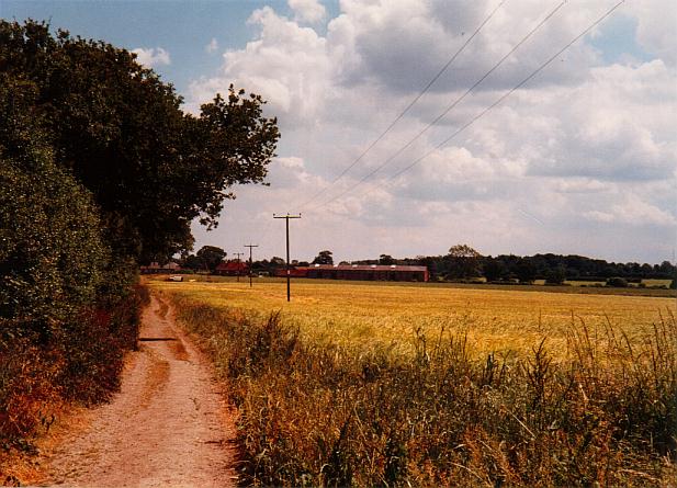
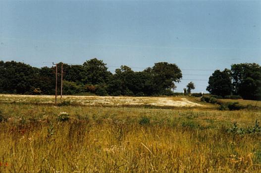
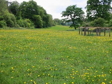
The land was eventually to be purchased from the Bailey family in the 1960's by the Commission for New Towns, but as the land itself was never used for housing, then it was leased to the Bell-Taylors of Westwick Row Farm who farmed the land until ownership was transferred to DBC in 1995. In the last few years before its transfer to DBC it was used for arable crops such as Rape and wheat. This picture shows the view from the public footpath, which connects Bunkers Lane & Chambersbury Lane, looking towards Bunkers Farm from near Chambersbury Lane, during the summer of 1994. The crop (the last to be grown) was wheat. Since then it has been developed into the present Bunkers Park.
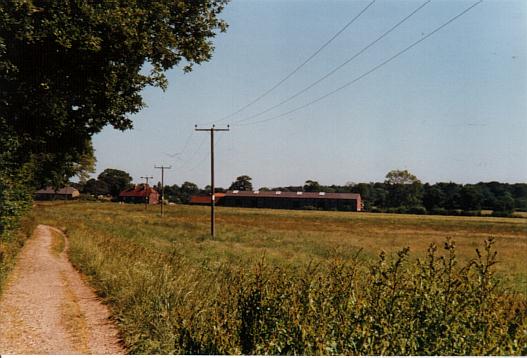
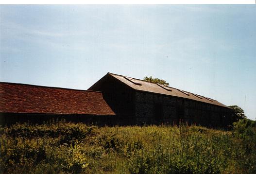
Above is a similar view taken the following year, with the farm buildings shown more clearly in the distance, and below a picture of the Bunkers Farm buildings from what is now the park in the summer of 1995.
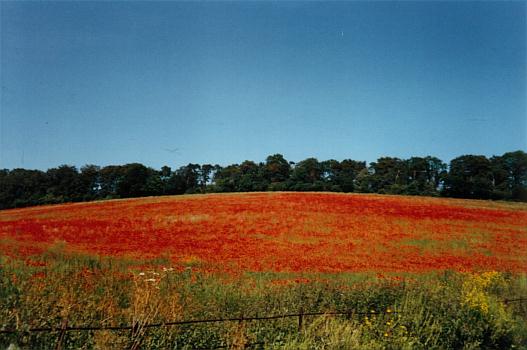
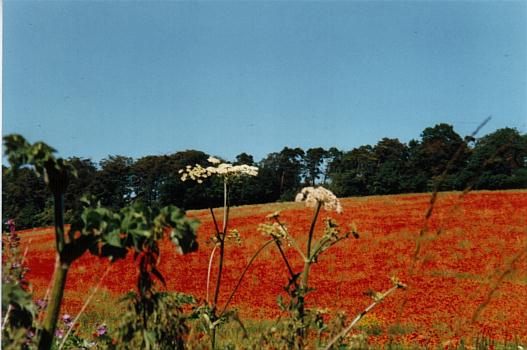
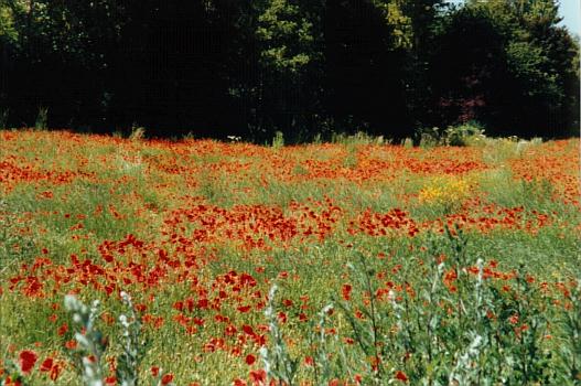
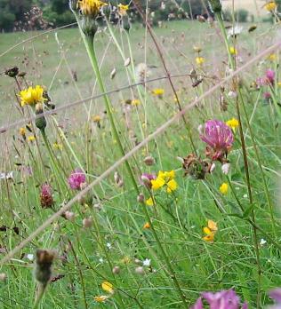
As in Flanders at the end of WWI, the first year following the cessation of cultivation other than just ploughing the land, much of what is today Bunkers Park was covered in red poppies. It was a particularly glorious site on the sloped area of the park forming a dry valley beyond the woodland band. (See photographs.)
Close up of the poppies in Bunkers Park summer 1995