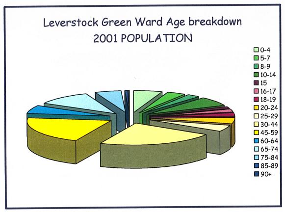
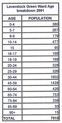
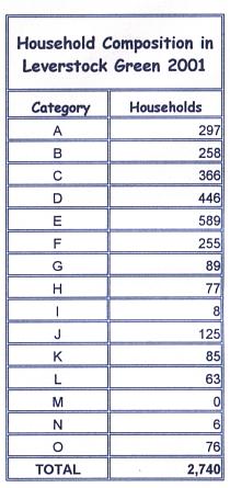
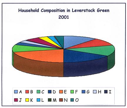
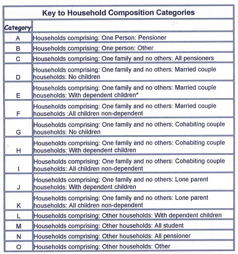
"Source: 2001 Census, [Key Statistics for Local Authorities]. Crown copyright 2004. Crown copyright material is reproduced with the permission of the Controller of HMSO "
Every 10 years there is a census in the UK, the last being in 2001.  Until 100 years after the census only generalised information can be released so as not to identify individuals.  The census in times past was conducted on a parochial basis (see 1851  1881 and 1901 census), but in recent census returns,  figures are collected on the basis of electoral wards. 
The results below relate to the electoral ward of Leverstock Green within the borough of Dacorum.  The village of Leverstock Green, however, stretches a bit further, and so is actually a little larger.  NOT included in these figures (and until 2101 we won't be able to glean the relevant information) are those households who live within Nash Mills Ward and St. Michael's Ward (St. Albans).  That is all those who live in Woodfield Gardens and Close, the far end of Bedmond Road beyond Woodfield Gardens, and those who live along Westwick Row towards St.Albans, beyond Dell Cottage.  This includes Westwick Row Farm, Westwick Warren and Corner Farm.  Some residents of Leverstock Green also live on the far side far the dual carriageway in Vauxhall & Raneleigh Roads, Woodend Close, Hales Park and Crest Park. The above probably amount to no more than 300 persons.
This page was last updated: April 4, 2011
National Census Online
"Source: 2001 Census, [Key Statistics for Local Authorities]. Crown copyright 2004. Crown copyright material is reproduced with the permission of the Controller of HMSO "
Click to link to official webpage on 2001 census
Click on logo to go to official website.
Click to link to principle LG Chronicle web pages.

Leverstock Green ChronicleMaplinks page (for large scale and old maps of the area.)

20th Century Leverstock GreenGlossary
THE LEVERSTOCK GREEN CHRONICLE
Add this page to your favorites.
Tell a friend about this page